


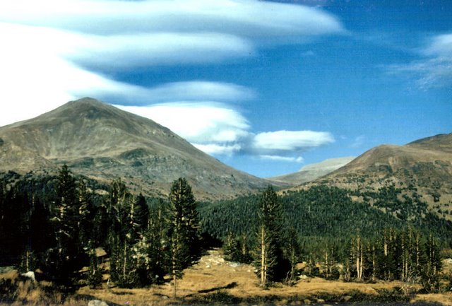
 As you can see from this shot I took while we were leaving Yosemite National Park, Tuolumne Meadows is a stunningly picturesque subalpine region is a great place to camp and hike with many varied trails. It is near the Western entrance to Yosemite. This area is only accessable by car during the summer via Tioga Road. This is the way we actually exited the park after coming in a week earlier from the Southern entrance (route 41 by the Mariposa Grove).
Tioga Road — the most famous scenic drive in Yosemite Park and it stretches 39 miles from Crane Flat to Tioga Pass through forests, meadows, lakes and granite domes. Open in summer only, the Tioga Road was originally a wagon road across the Tioga Pass built by the Great Consolidated Silver Company in 1883.
Tioga Pass — where Tioga Road (Highway 120) enters Yosemite Park's Western edge, crosses the Sierra Nevada's crest at an elevation of 9,945 feet and is California's highest automobile pass.
Tuolumne Meadows is a gentle, dome-studded meadowy section of the Tuolumne River, in the eastern section of Yosemite National Park. Its approximate location is just a few miles from the town of Lee Vining down below (as the crow flies) but several more miles as the car drives slowly down the very steep mountain grades from the meadows to the desert plaines below. The meadows are at an approximate elevation is 8619 feet (2627 m). And Lee Vining, California is an unincorporated town in Mono County, California. The town has a total population of only 488 and its elevation is only 6781 feet. It is located on the southwest shore of Mono Lake.
The economy of the little town of Lee Vining relies largely on tourism, since it is the closest town to the east entrance of Yosemite National Park, and is near other tourist destinations such as Mono Lake, the ghost town of Bodie, popular trout fishing destinations, and June Mountain and Mammoth Mountain ski areas and the June Lake recreational area. Tourism is mostly confined to the summer months, because California State Route 120 through Yosemite is closed otherwise because of heavy snows, although they say that year-round tourism has been increasing in recent years.
Tuolumne Meadows has a good view of the Cathedral Range (in the background of the image, looking south), Lembert Dome and Mount Dana (to the north). Camping is available at the Tuolumne Meadows campground. Excellent hiking and rock climbing are accessible from Tuolumne Meadows, which tends to be less crowded than Yosemite Valley.
The John Muir Trail and the Pacific Crest Trail run through Tuolumne Meadows. Downstream (flowing to the right (western) side of the image), the Tuolumne River cascades over Waterwheel Falls, near Glen Aulin, eventually pooling at Hetch Hetchy.
All in all, this is just a small slice of the beauty that abounds in the part of the country of the Sierra Nevada's. This reminds me that I may want to do a blog post someday, about the Ghost Town of Bodie, California.
"Travel at its truest is thus an ironic experience, and the best travellers . . . seem to be those able to hold two or three inconsistent ideas in their minds at the same time, or able to regard themselves as at once serious persons and clowns." -Paul Fussell