


 British Virgin Islands (BVI) is the perfect destination. They are located about 50 miles (80 kilometers) east of Puerto Rico at the eastern end of the Greater Antilles, right smack in the Caribbean Sea. The BVI’s slogan, "Nature’s Best Kept Secret," couldn’t be more true.
Virgin Gorda is a volcanic island that’s ten miles long and two miles wide with a population of about 5,000. It is most distinguishable for the large boulders scattered about, unusual rock formations, and caves, inland and on the beaches. The north half of Virgin Gorda is mountainous, with a peak that rises to 1,370 feet. The south half of the island is relatively flat.
Virgin Gorda has 20 secluded beaches. The most popular are Devil's Bay, Spring Bay, and Trunk Bay, which are on the West Coast of the island. At the northern tip of the island is North Sound National Parks. Prickly Pear Island is to the north, and Mosquito Island is to the West.
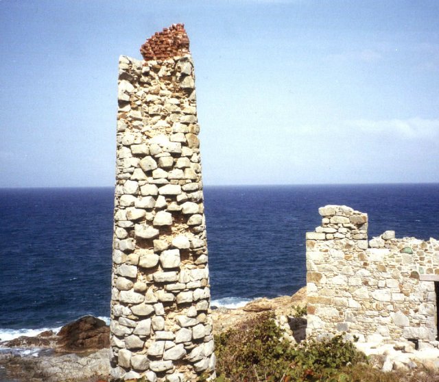
All land on Virgin Gorda over 1,000 feet in elevation has been designated part of the BVI National Parks Trust. One such area on the southeast tip is Copper Mine Point. Here you will find the vestiges of the site where the Spaniards mined copper, gold and silver some 400 years ago.
The area’s rocky façade is similar to what is found on the Cornish coast of England. As you explore the area you will notice many interesting stones, minerals, and crystals embedded in quartz; but don’t plan on taking any home – everything is protected because this site is part of a national park.
The copper mine is one of the most beautiful and interesting sites on Virgin Gorda, but exploring the ruins can be dangerous, and visitors are urged to be cautious. The boiler house and chimney have badly deteriorated, and there are many loose rocks around entrances to timbered-up shafts that lie several feet below ground level. There are also five abandoned prospecting shafts, each about sixty feet deep, at the top of the hill, above the stack.
According to local legends, the shafts were originally dug by Spanish adventurers to mine silver in the late-fifteenth century, but no documentary evidence can be found to support this theory. All extant records show the shafts were first sunk by an English group in 1838 to mine copper. A lack of working capital brought operations to a halt four years later. The mine was reopened in 1859 and worked until 1867, when operations ceased.
Lovers' Lane ~ Where the paved road ends toward Coppermine Point, (not far from where I took this shot) on this wild coast of entrancing beauty, of moonlit cliffs overhanging the pounding surf glowing white far below, is Virgin Gorda's Lovers' Lane. Toward the opposite shore is the Virgin Gorda airport for smaller planes. Further still is Coppermine Point on the tip of Virgin Gorda, the site of an 400 year old copper mine. This shot I too, comes from a day tour of the island that we took while on a cruise stop on the Island.
The island was primarily known for its Baths. The Baths take their name from huge granite boulders, which have toppled over one another, forming beautiful salt-water grottoes, ideal for bathing and exploring. Boulders like these and ones scattered across the Valley were formed tens of millions of years ago when volcanic lava cooled in huge chunks of granite. The continual work of the elements washed away light topsoil, exposing the boulders and giving them the smooth, rounded appearance they have today.