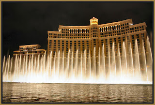
 You know for some reason I looked at the photos on the template of my blog today and realized that there is a photo up there of a place that I have yet to post on this blog about. As I have posted that photo right here on this post, you more than likely have already broken the code and figured it out. But what about this town of gambling, showgirls, cards, dice, and even dreams and diasters. How did it all get to where it is today? Well... the exact date is unknown, but Rafael Rivera became the first known non-Indian to set foot in the oasis-like Las Vegas Valley.
The abundant artesian spring water discovered at Las Vegas shortened the Spanish Trail to Los Angeles, eased rigors for Spanish traders and hastened the rush west for California gold. Between 1830 and 1848, the name "Vegas," as shown on maps of that day, was changed to Las Vegas which means "The Meadows" in Spanish. Some 14 years after Rivera's discovery, John C. Fremont led an overland expedition west and camped at Las Vegas Springs on May 13, 1844.His name is remembered today in neon as well as museums and history books. The Fremont Hotel-Casino in Downtown Las Vegas bears his name as does Fremont Street -- the main thoroughfare through the heart of casino-lined Glitter Gulch.
Mormon settlers from Salt Lake City traveled to Las Vegas to protect the Los Angeles-Salt Lake City mail route and in 1855 began building a 150-square-foot fort of sun-dried bricks made of clay soil and grass, a substance known as adobe. The Mormons planted fruit trees, cultivated vegetables and mined lead for bullets at Potosi Mountain. Mormon pioneers abandoned the settlement in 1858, partly because of Indian raids. A portion of the "Mormon Fort" has withstood the ravages of time and is an historic site today near the intersection of Las Vegas Boulevard North and Washington Avenue. Scientists began an archeological dig on the site in November 1999.
Members of the Church of Jesus Christ of Latter-Day Saints (Mormons) currently make up about 12 percent of the Southern Nevada population and in December 1989 dedicated a Mormon Temple in Las Vegas. The temple spires are visible in the foothills of Sunrise Mountain to the east of the city.
By 1890 railroad developers had determined the water-rich Las Vegas Valley would be a prime location for a stop facility and town. More than a quarter century earlier, Nevada, known as the Battle Born State, had been admitted to the Union in 1864 during the Civil War.
Work on the first railroad grade into Las Vegas began the summer of 1904. The tent town called Las Vegas sprouted saloons, stores and boarding houses. Rails were connected with the eastern segment of track in October 1904. The San Pedro, Los Angeles and Salt Lake Railroad, later absorbed by its parent the Union Pacific, made its inaugural run from California to points east on Jan. 20, 1905.
The railroad yards were located at the birthplace of a partially paved, dusty Fremont Street. Jackie Gaughan's Plaza Hotel, located at Main and Fremont streets in Downtown Las Vegas, today stands on the site of the original Union Pacific Railroad depot. Freight and passenger trains still use the depot site at the hotel as a terminal -- the only railroad station in the world located inside a hotel-casino.
Advent of the railroad led to the founding of Las Vegas on May 15, 1905. The SanPedro, Los Angeles and Salt Lake Railroad, owned by Montana Senator Williams Andrews Clark, auctioned off 1,200 lots in a single day in an area which today is casino-lined Glitter Gulch.
Nevada was the first state to legalize casino-style gambling, but not before it reluctantly was the last western state to outlaw gaming in the first decade of the 20th Century. At midnight, Oct. 1, 1910, a strict anti-gambling law became effective in Nevada. It even forbid the western custom of flipping a coin for the price of a drink.The Nevada State Journal newspaper in Reno reported: "Stilled forever is the click of the roulette wheel, the rattle of dice and the swish of cards."Forever" in this case, lasted less than three weeks in Las Vegas.
Gamblers quickly set up underground games where patrons who knew the proper password again jousted day and night with Lady Luck. Illegal but accepted gambling flourished until 1931 when the Nevada Legislature approved a legalized gambling bill authored by Phil Tobin, a Northern Nevada rancher. Tobin had never visited Las Vegas and had no interest in gambling.
He said the legalized gambling legislation was designed to raise needed taxes for public schools. Today, more than 43 percent of the state general fund is fed by gambling tax revenue and more than 34 percent of the state's general fund is pumped into public education.
Legalized gambling returned to Nevada during the Great Depression. It legitimized a small but lucrative industry. That same year construction started on the Hoover Dam Project which, at its peak, employed 5,128 people.
The young town of Las Vegas virtually was insulated from economic hardships that wracked most Americans in the 1930s. Jobs and money were prevalent because of Union Pacific Railroad development, legal gambling and construction of Hoover Dam 34 miles away in Black Canyon on the Colorado River.
World War II stalled major resort growth in Las Vegas. But the seeds for future expansion had been planted in 1941 when hotelman Tommy Hull built the El Rancho Vegas Hotel-Casino on what is now vacant land opposite the current Sahara Hotel on the Las Vegas Strip.
During World War II, nearby Nellis Air Force Base grew into a key military installation. Originally built to train B-29 gunners, it later became the training ground for the nation's ace fighter pilots. Many key military personnel assigned to Nellis during World War II later returned as civilians to take up permanent residency in Las Vegas. Today thousands of people are connected to Nellis in the form of active duty personnel, civilian employees, military dependents and military retirees.
The success of the El Rancho Vegas triggered a small building boom in the late 1940s including construction of several hotel- casinos fronting on a two-lane highway leading into Las Vegas from Los Angeles. The stretch of road evolved into today's Las Vegas Strip. Early hotels included the Last Frontier, Thunderbird (Still standing as the Arubu Hotel & Spa) and Club Bingo. The El Rancho Vegas was razed by fire on June 17, 1960. As time passed, many other first-generation Strip resorts lost their identity through absorption by new owners, demolition, extensive renovation and name changes.
By far the most celebrated of the early resorts was the Flamingo Hotel, built by mobster Benjamin "Bugsy" Siegel, a member of the Meyer Lansky crime organization. The Flamingo with a giant pink neon sign and replicas of pink flamingos on the lawn, opened on New Year's Eve 1946. Six months later, Siegel was murdered by an unknown gunman who fired a shotgun blast as Siegel sat in the living room of the Beverly Hills, Calif., home of his girlfriend, Virginia Hill.
Siegel's life was the subject of a 1992 movie entitled "Bugsy." Although the historic accuracy of the movie is questionable, the movie prompted the Flamingo to open the "Bugsy Celebrity Theater" in November 1992. The Flamingo, after numerous ownership changes, is now owned and operated by the Hilton Hotel Group. Its proper name is the Flamingo Hilton.
While the El Rancho Vegas and other 1940s resorts followed a western ranch-styled theme, the Flamingo was what Siegel called a "carpet joint." It was modeled after resort hotels in Miami. Only the Flamingo Hotel name has survived the 1940s era of Las Vegas Strip development. The final end of the Flamingo as Bugsy knew it was announced early in 1993 when Hilton Corp. revealed plans to construct a $104 million tower addition at the Strip resort -- the last of a six tower master plan. The addition opened in the spring of 1995.
Architectural plans included razing the outmoded, motel-style buildings at the rear of the property, dooming the fortress-like "Bugsy Suite" and bullet proof office used by the gangster before his death in 1946. In December 1993, the last remnants of Bugsy Siegel and his residence were destroyed when the hotel bulldozed the Oregon Building that held the suite in which the gangster once lived.
Well... I have gone on and on so much about the history of this place, that I may have to do multiple posts in order to cover not only my photos, but also to cover what Mrs. LZ and I actually did during our trip here.
“People who invite trouble always complain when it accepts." ~ Lane Olinghouse


