With the first day of fall right behind us and the feel of fall right around the corner here in the Midwest, I was reminded of a fall foliage trip that we went on a few years ago. We flew in to Boston's Logan Airport and took several days going all over Massachetts, Rhode Island, Connecticut, Maine, New Hampshire and Vermont. One of the most beautiful places (of many) that we found was a little place called Woodstock, Vermont. Words like romantic, magical and historic are often used to describe this quaint village that has been called "the prettiest small town in America." First settled in 1768, Woodstock retains the elegant charm and rugged character of American antiquity. With a covered bridge in the middle of town, and stately homes surrounding the village green, it is easy to see why Woodstock has been called the "quintessential New England village." You will be greeted with traditional New England hospitality in our unique shops and galleries, artisan studios, country stores and fine restaurants. One of those was a place called the “Woodstock Inn & Resort”. It was located in the center of Vermont in the village of Woodstock, (known as the prettiest small town in America). The Inn defines sophistication without pretension, with its Four Diamond lodgings; three restaurants, including the exquisite Four Diamond-rated Main Dining Room; world-class amenities such as golf, tennis, skiing (both downhill and cross-country); and superb health and fitness offerings. It was very close to where I took this shot from. The Inn is surrounded by all the best of Vermont: beautiful scenery, charming shops and galleries, historic covered bridges, a national park, a working dairy farm from the 1800s. So, too, the Inn’s 142 newly refurbished guest rooms and suites reflect Vermont at its finest. Original artworks by noted regional artists grace the walls. Custom designed furniture and adornments fill the guest rooms, many of which have the kind of real fireplaces often imagined but seldom found. Recently remodeled bathrooms offer every amenity, like heating lamps and oversized shower heads, which soothe and pamper. Nestled in the heart of Vermont, Woodstock is a synonym for timeless beauty. Clear blue skies, babbling brooks, fields of flowers and pastoral farms envelop and delight as you enjoy the unhurried pace of life. Woodstock maintains a vibrant cultural heritage, continued today in a variety of venues: The Marsh-Billings-Rockefeller National Historical Park (Vermont's only national park), The Billings Farm & Museum, Vermont Institute of Natural Science (VINS), and The Pentangle Council on the Arts, just to name a few. Embodying Vermont's natural way of life, Woodstock offers visitors convenience to world class hiking, skiing, biking, fishing, and golfing as well as playing host to some of America's premier outdoor events. I would strongly recommend a stop in this area at any time you happen to get close, but really the beauty of FALL in Vermont is absolutely breathtaking. "A journey is like marriage. The certain way to be wrong is to think you control it." -John Steinbeck 
|
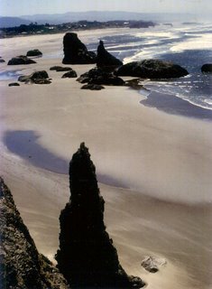 This particular beach was very unique, yet one of the most beautiful ones that we saw in our last trip along the Oregon Coast. There was another beach, that was known for its huge sand dunes also along this byway. I have never seen the like of those dunes anywhere else in the world that I have ever been. This whole drive along the Oregon coast offered lush evergreen forests; picturesque coastal scenery, rugged cliffs, impressive sand dunes and vast sandy beaches awaited us around every corner along the Pacific Coast Scenic Byway, US Highway 101. The Oregon coast has fully developed resort communities with every possible amenity to quiet coastal towns where the loudest sounds you'll hear are waves on the shoreline and seagulls overhead. The down-home environment of hospitality every season of the year makes the Oregon coast memorable. There are many recreational opportunities from fishing, cycling, flying a kite on the beach, scuba diving, hiking through old-growth forests, windsurfing and surfing, beachcombing, whale and bird watching... the list is almost endless. There are also many coast attractions including aquariums, art galleries, theaters and festivals, parades and poetry readings. Many lighthouses dot the Oregon coast and you can find hundreds of parks to explore. We spent a night in one of them that was just full of prehistoric ferns and pine trees. I thought that it was quite unique that the campsite was stocked full of free firewood for the fire pit that was right in the center of the campsites. The solitude of the quiet months on the coast brings relaxing stretches of peaceful beaches, untouched tidal pools, spectacular sunsets and nights beneath star-strewn skies. Storm watching during winter months captures your breath as crashing waves pound the rocky beaches and send water shooting into the sky. This shot was not far from where we camped, (only we were not on the beach side of the byway). This was taken somewhere south of Coos Bay in an area that I think was called Bandon Beach. Brandon awaits the beachcomber, the explorer, the artist and the dreamer. Located along Bandon's Beach Loop Road, there are several locations with beach access, picnicking and unsurpassed views. The particular structures that I captured in this shot, looked almost like they could have been put there by “someone” similar to the carved structures on beaches in the Canary Islands. You have to use a little imagination to conjure that up, but I did, none-the-less! The Oregon coast has beaches all along Hi-way 101 all the way from Astoria on the North down to Brookings-Harbor on the south side of the state. Places like Seaside, Cannon Beach, Garibaldi, Lincoln City, Walport, Florence, North Bend, Coos Bay and Gold Beach, are all easy to reach from the highway. Most of these cities have their own state beaches and most have just beautiful vistas of not only the Pacific Ocean but also of the surrounding forests, sand dunes, rock formations and varieties of vegetation that spot this beautiful part of the Northwestern United States. "All journeys have secret destinations of which the traveller is unaware." -Martin Buber
|
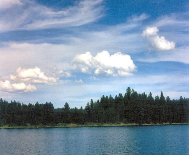
 For a vacation one year we rented a cabin in the mountains of Idaho. It came complete with its own river and dock right out of our front door. The rental also included a motor boat which we found handy, not only for water skiing but also for trips up the river where there just happened to be a Pizza place with its own boat dock for Pizza lovers. If you kept going up the river you would actually get to the dam which created Lake Pend Oreille. One of the really cool things that we did while we were there, was to take a tour of an old lumber mill. It was not what you would really consider a "Disneyland" kind of tour, but more like some family owned business that was "happy to have someone come to visit their place" kind of tour. We found it just facinating. There is actually a city that is called Priest River, Idaho too, in addition to just the river itself. It is centrally located in a recreation paradise, nestled in the Selkirk Mountain Range. It is bordered by the Priest River on the east and the Pend Oreille River on the south. It is just 7 miles east of Washington, and 75 miles south of Canada. Spokane - Washington, and Coeur d' Alene - Idaho are an hour drive away. As you become acquainted with the City hope you will be able to visualize the beauty and abundant natural resource areas available at their doorstep. The City of Priest River is centrally located in a recreational paradise, nestled in the mountains, and is bordered by rivers on the East and to the South. The community itself has a population of about 1800, with an additional 3500 in surrounding areas. The County Seat, located in Sandpoint, Idaho, is just 22 miles East on Highway 2. The elevation of Priest River is about 2100 feet. Their climate is moderate with an average maximum temperature of 57 degrees and average minimum of 34 degrees. Summer temperatures are not often above 90, with delightfully cool evenings. I don't think it got over 85 in the week that we were there. They say that the fall air is usually crisp and clear. Average snowfall is approximately 72 inches, with rarely more than two feet on the ground. Priest River (the city) is a member of The International Selkirk Loop, a traveling circuit exploring more than two dozen towns located throughout Idaho, Washington, and the Canadian Province. As a member of the Loop they have been featured in Sunset Magazine for the past two years! If you ever happen to be in the area, it is worth stopping and taking a look. The natural beauty and clear bright blue skies are just breath taking. This picture can not do it justice. But really what picture can? "Stripped of your ordinary surroundings, your friends, your daily routines, your refrigerator full of food, your closet full of clothes - with all this taken away, you are forced into direct experience. Such direct experience inevitably makes you aware of who it is that is having the experience. That's not always comfortable, but it is always invigorating." -Michael Crichton
|
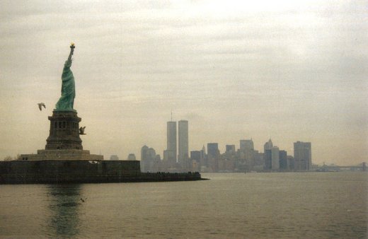
 It has been several years since I took this photo and obviously it was prior to the terrorist attacks on the World Trade Center Towers on September 11, 2001. I took it from one of the Liberty Ferrys that leave Battery Park and go out to the Statue of Liberty and Ellis Island. I so wish that the skyline of Lower Manhattan still looked like this, but more importantly than the skyline, were the 2996 lives that were lost on that day as a direct result of this attack against our country and our way of life. This photo and the darkness of the Statue of Libery looming over the Manhattan Skyline seems like a precursor to things to come. It also shows that "LIBERTY" still stands. As for the Twin Towers and the terrible suffering those cowardly terrorists brought to our country was just EVIL! The buildings can be rebuilt, but the lives that were lost and the damage to their families can never be repaired. Let us "NEVER FORGET" this DAY of 21st Century infamy. The concept of a World Trade Center complex originated with Nelson and David Rockefeller in the 1950s as an attempt to revitalize lower Manhattan. The initial proposed site on the East River was later moved to the lower west side. The complex towers were designed by Japanese American architect Minoru Yamasaki with Antonio Brittiochi in one of the most striking American implementations of the architectural ethic of Le Corbusier, as well as the seminal expression of Yamasaki's gothic modernist tendencies. In 1966, construction of the World Trade Center began with a groundbreaking that razed 13 square blocks of low-rise buildings, some of which predated the US Civil War. The construction was under the auspices of the semi-autonomous Port Authority of New York and New Jersey. In 1970, construction was completed on One World Trade Center, with its first tenants moving into the building in December 1970. Tenants first moved into Two World Trade Center in January 1972. The ribbon-cutting ceremony was on April 4, 1973. Ultimately the complex came to consist of seven buildings, but its most notable features were the main twin towers. On any given day, some 50,000 people worked in the towers with another 200,000 passing through as visitors. The complex was so large that it had its own ZIP Code: 10048. Although the towers became an undeniable icon of New York City, they were not without their flaws and were troubled in many ways. Initially conceived, (as the name suggests) as a complex dedicated to companies and organizations directly involved in "world trade," they at first failed to attract the anticipated clientele; during the WTC's early years various governmental organizations became key tenants. It was not until the 1980s that the city's perilous financial state eased, after which an increasing number of private companies — mostly financial firms tied to Wall Street — became tenants. Moreover, the trade center's "super block", which replaced a more traditional, dense neighborhood, was regarded by some critics as an inhospitable environment that disrupted the intricate flows of traffic typical of Manhattan. For example, in his book The Pentagon of Power, the technical historian Lewis Mumford denounced the center as an "example of the purposeless giantism and technological exhibitionism that are now eviscerating the living tissue of every great city." Also, at the center of the complex, the immense Austin J. Tobin Plaza (named after the former executive director of the Port Authority of New York and New Jersey who oversaw the WTC's construction) was perpetually unpopular among New Yorkers. However, the towers offered spectacular views from the observation deck (located on top of the South Tower) and the Windows on the World restaurant (located on top of the North Tower). The trade center had its many admirers, particularly out-of-towners. For those who deemed it cold and sterile, there were just as many who appreciated its sheer immensity; some even took advantage of it. French high wire artist Philippe Petit walked between the towers on a tightrope in 1974, and Brooklyn toymaker George Willig scaled the south tower in 1977. Memorable moments such as these lent the World Trade Center a sense of humanity in ways that became immortalized in New York City legend. Each of the WTC towers had 110 stories. 1 WTC (the North Tower, which featured a massive 360 foot high TV antenna added in 1978) stood 1,368 feet (417 m) high, and 2 WTC (the South Tower, which contained the observation deck) was 1,362 feet (415 m) high. The length and breadth of the towers were 208 feet (63.4 m) x 208 feet (63.4 m). Although only Tower 1 featured an antenna, the structure of both buildings was designed to carry a broadcast mast. When completed in 1972, 1 WTC became the tallest building on Earth, unseating the Empire State Building after a 40-year reign. 2 WTC became the second tallest building in the world when completed in 1973. The difference in height between the two towers was because of a Port Authority request to have two floors, the 43rd and the 67th, in 1 WTC raised, the lower of the taller floors being a cafeteria for PANY workers. 2 WTC did not need these facilities, so it remained 1,362 feet. Regardless, the WTC towers held the height record only briefly. As the building neared completion in 1973, work had already begun on Chicago's Sears Tower, which ultimately reached 1,450 feet (442 m). With the World Trade Center's destruction, the Empire State Building again became the tallest building in New York, after spending almost 30 years as the third tallest in the city. The towers' sheer size was the subject of a joke during a press conference unveiling the landmarks. Minoru Yamasaki was asked: "Why two 110-story buildings? Why not one 220-story building?" His response was: "I didn't want to lose the human scale." Another joke was that the towers looked like the boxes that the Chrysler Building and Empire State Building came out of. Writer Paul Fussell declared them to be reminiscent of Third Reich architecture for being "brutal and despotic," and being "dull and witless, expressive only of dumb raw power." What the twin towers may have lacked in architectural aestheticism, they made up for with engineering innovation. To solve the problem of wind sway or vibration in the construction of the towers, chief engineer Leslie Robertson took a then unusual approach — instead of bracing the buildings corner-to-corner or using internal walls, the towers were essentially hollow steel tubes surrounding a strong central core. The 208 feet (63.4 m) wide facade was, in effect, a prefabricated steel lattice, with columns on 39-inch (100 cm) centers acting as wind bracing to resist all overturning forces; the central core took the majority of the gravity loads of the building. A very light, economical structure was built by keeping the wind bracing in the most efficient area, the outside surface of the building, thus not transferring the forces through the floor membrane to the core, as in most curtain-wall structures. The core supported the weight of the entire building and the outer shell containing 240 vertical steel columns called Vierendeel trusses around the outside of the building, which were bound to each other using ordinary steel trusses. In addition, 10,000 dampers were included in the structure. With a strong shell and core such as this, the exterior walls could be simply light steel and concrete. With the massive core and lightweight shell for structural integrity, Robertson created a tower that was extremely light for its size. This method of construction also meant that the twin towers had the world's highest load-bearing walls. The excavation of the foundations of the WTC complex, known as the Bathtub, located on the former Radio Row, was particularly complicated since there was two subway tubes close by needing protection without service interruption. A six-level basement was built in the foundations. The excavation of about 1 million cubic yards (760,000 m³) of earth and rock created a $90 million real estate asset for the project owner, the Port Authority of New York and New Jersey, which helped offset the enormous loss in revenues which came from the tax breaks given to the Trade Center itself. The soil was used to create 23 acres (93,000 m²) of landfill in the Hudson River next to the World Trade Center site, which became the site of Battery Park City (still under development). One of the world's largest gold depositories was stored underneath the World Trade Center, owned by a group of commercial banks. The 1993 bomb detonated close to the vault, but it withstood the explosion, as did the towers. Seven weeks after the September 11th attacks, $230 million in precious metals were removed from basement vaults of 4 WTC, which included 3,800 100-Troy-ounce registered gold bars and 30,000 1,000-ounce silver bars. We not only lost the twin Towers on this day five years ago, but we also lost the innocence that let us all believe that the United States could never be attacked on our own continental U.S. soil. On that day we saw the FACE OF EVIL! People dedicated to destroying our "way of life" and the freedoms by which we live our lives. LET US NEVER FORGET!"Courage is the first virtue, without it, none of the others matters." ~ Winston Churchill
|
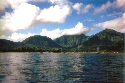
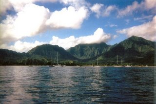 Famous for its spectacular beauty, Hanalei Bay is a long half-moon of sandy beach carved into the base of a sheer cliff on one side and narrowing into a rocky point on the other. As you can see I took this picture while we were actually in the bay. We decided that a Zodiac Boat trip to the Napali coast was the ticket for the day. Maybe not one of my better ideas retrospectively! The beach is a great spot for walking or throwing a Frisbee around. At the westernmost curve of the bay, you'll find a calm shoreline where the water is relatively quiet even when most of the north shore is too rough for safe swimming. We found out just how ruff it gets once we left the tranquility of this bay. The Zodiac Boats were one of the most exhilarating (and scariest rides I have ever been on). It was almost as if the driver was intent on trying to lose someone off of his boat (just for kicks)! Though the main center for tourism on the North Shore, PRINCEVILLE is not exactly a town; it's too short of shops, public amenities, or even a permanent population. Instead it's a "planned resort community" consisting of neat rows of quasi-suburban vacation homes mixed in with a few larger condo complexes, two golf courses and a couple of luxury hotels. The general sense of placid domesticity is somehow heightened by the fact that the whole place is overlooked by the magnificent mountain wilderness that fills the western horizon. Princeville stands on a well-watered plateau that abuts Hanalei Bay to the west and the open ocean to the north. Once this was the site of a sprawling grove of hala (pandanus) trees. In contrast to the common farming lands of Hanalei Valley below, it served as a residential area for the island's elite. Soon after Europeans arrived on the island, the Russian-backed German adventurer George Schäffer renamed this district "Schäffertal" and constructed the short-lived Fort Alexander on the Pu'u Poa headland now occupied by the Princeville Hotel. The general outline of the fort is still discernible on the lawn near the main hotel entrance. In its centre, a small pavilion holds explanatory displays and enjoys superb views across the bay to Lumaha'i Beach and beyond. In the 1830s, the British consul Richard Charlton leased most of the land between Kilauea and Hanalei to pasture a herd of one hundred cattle. He failed to pay his rent, however, and after the Great Mahele, Robert Crichton Wyllie, Hawaii's Foreign Minister for twenty years, acquired the land. Wyllie built an overambitious sugar mill beside the Hanalei River, equipped with machinery imported from his native Scotland. King Kamehameha IV, Queen Emma and the young Prince Albert visited him in 1860. The name "Princeville," adopted in Albert's honor, has stuck ever since, although Albert died two years later at the age of four. Just four months after Wyllie died in 1865, his nephew and heir committed suicide upon realizing that he had inherited a mountain of debt. Sheep farming subsequently proved no more profitable than sugar, and Princeville was, until 1969, a cattle ranch. The entire area was then bought by an American consortium, and work started on the construction of the resort. Its centerpiece, the Princeville Hotel, opened in 1985 and has changed hands repeatedly ever since, while continuing to rank among the world's top tropical hideaways. Princeville was hit especially hard by Hurricane Iniki in 1992; for several days the Princeville Hotel served as a makeshift community shelter, despite losing most of its roof and its entire tenth floor. Now things are back to normal, and Princeville can't be faulted as a relaxing base from which to explore North Kauai. Though, in truth, there's nothing in particular to see, and the pretty little beaches tucked beneath the cliffs are no better than countless others along this stretch of coast. Don't get me wrong here, the sea caves we went into while at the Napali Coast were spectacular, and the view of Napali Coast from the Zodiac Boat, was just unbelievably beautiful. But if I had it all to do over again, I would recommend the catamarans which go to the same area, (sans the sea caves). You still get the nice picnic at the bottom of the cliffs and you don't have to worry about loosing your lunch on your way back to Hanalei Bay at Princeville. ". . .travel is more than the seeing of sights; it is a change that goes on, deep and permanent, in the ideas of living." -Miriam Beard
|
|


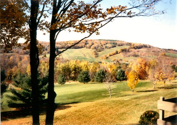 With the first day of fall right behind us and the feel of fall right around the corner here in the Midwest, I was reminded of a fall foliage trip that we went on a few years ago. We flew in to Boston's Logan Airport and took several days going all over Massachetts, Rhode Island, Connecticut, Maine, New Hampshire and Vermont. One of the most beautiful places (of many) that we found was a little place called Woodstock, Vermont.