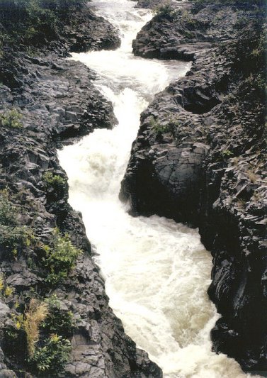
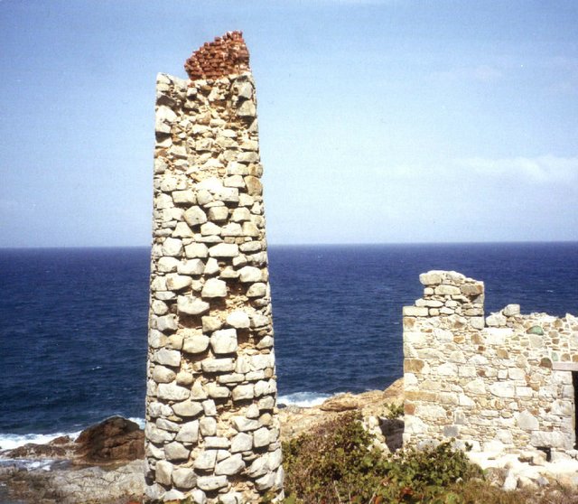
British Virgin Islands (BVI) is the perfect destination. They are located about 50 miles (80 kilometers) east of Puerto Rico at the eastern end of the Greater Antilles, right smack in the Caribbean Sea. The BVI’s slogan, "Nature’s Best Kept Secret," couldn’t be more true. Virgin Gorda is a volcanic island that’s ten miles long and two miles wide with a population of about 5,000. It is most distinguishable for the large boulders scattered about, unusual rock formations, and caves, inland and on the beaches. The north half of Virgin Gorda is mountainous, with a peak that rises to 1,370 feet. The south half of the island is relatively flat. Virgin Gorda has 20 secluded beaches. The most popular are Devil's Bay, Spring Bay, and Trunk Bay, which are on the West Coast of the island. At the northern tip of the island is North Sound National Parks. Prickly Pear Island is to the north, and Mosquito Island is to the West. All land on Virgin Gorda over 1,000 feet in elevation has been designated part of the BVI National Parks Trust. One such area on the southeast tip is Copper Mine Point. Here you will find the vestiges of the site where the Spaniards mined copper, gold and silver some 400 years ago. The area’s rocky façade is similar to what is found on the Cornish coast of England. As you explore the area you will notice many interesting stones, minerals, and crystals embedded in quartz; but don’t plan on taking any home – everything is protected because this site is part of a national park. The copper mine is one of the most beautiful and interesting sites on Virgin Gorda, but exploring the ruins can be dangerous, and visitors are urged to be cautious. The boiler house and chimney have badly deteriorated, and there are many loose rocks around entrances to timbered-up shafts that lie several feet below ground level. There are also five abandoned prospecting shafts, each about sixty feet deep, at the top of the hill, above the stack. According to local legends, the shafts were originally dug by Spanish adventurers to mine silver in the late-fifteenth century, but no documentary evidence can be found to support this theory. All extant records show the shafts were first sunk by an English group in 1838 to mine copper. A lack of working capital brought operations to a halt four years later. The mine was reopened in 1859 and worked until 1867, when operations ceased. Lovers' Lane ~ Where the paved road ends toward Coppermine Point, (not far from where I took this shot) on this wild coast of entrancing beauty, of moonlit cliffs overhanging the pounding surf glowing white far below, is Virgin Gorda's Lovers' Lane. Toward the opposite shore is the Virgin Gorda airport for smaller planes. Further still is Coppermine Point on the tip of Virgin Gorda, the site of an 400 year old copper mine. This shot I too, comes from a day tour of the island that we took while on a cruise stop on the Island. The island was primarily known for its Baths. The Baths take their name from huge granite boulders, which have toppled over one another, forming beautiful salt-water grottoes, ideal for bathing and exploring. Boulders like these and ones scattered across the Valley were formed tens of millions of years ago when volcanic lava cooled in huge chunks of granite. The continual work of the elements washed away light topsoil, exposing the boulders and giving them the smooth, rounded appearance they have today. 
|
 All the way along the "Road to Hana" as it is called (Highway 31, Southeast Maui) you can find all sorts of beauty. Once you finally make it to Hana, the road gets even tighter and more precarious to the timid driver, but the beauty of the area abounds every direction that you look. One of those beautiful sites is the Seven Sacred Pools. They are a series of lovely waterfalls and tranquil pools that flow through the O'heo Gulch and into the ocean nearby. The Pipiwai Streams feeds these falls and numerous pools starting 2 miles inland. The easiest to reach and the nicest pools are located near the shoreline. The land where the Seven Sacred Pools are situated was donated to the Haleakala National Park system so that the pools would forever be open to the public. This is a natural playground for locals and tourists alike. There is hiking, historical sites, "cliff" jumping, pool swimming, and interesting people watching. The area is always crowded on weekends and, even though there is a large gravel parking lot, it is often full. So as they say; "Come early to get a spot" or stay in Hana to assure an early arrival. The Pipiwai Trail, above the Seven Sacred Pools, is one of the best hikes on Maui. It is 4 miles roundtrip, gaining 650-feet in elevation. It takes 2 1/2 - 5 hours to hike, depending on how much nature loving you do. There are several great waterfalls along the route with the final destination being Waimoku Falls, falling 400-feet down a sheer lava rock wall. Along the Pipiwai Trail is Infinity Pool. It has a row of thick rocks that keep you from plunging over the 200-foot waterfall during normal flow times. This pool is much more secluded than the more popular Seven Sacred Pools. I took this shot, but it still doesn't show all of the pools and waterfalls that make up its namesake. At the end of this road is where Charles Lindbergh is buried. Lindbergh died of cancer on Aug. 26, 1974, in his home on the Hawaiian island of Maui. After his death, he was buried on the beautiful grounds of the Palapala Ho'omau Church (which is at the END of this road.) Lindbergh's grave is under the shade of a Java plum tree. Before he died, he sketched a simple design for his grave and coffin. The inscription reads: Charles A. Lindbergh Born: Michigan, 1902. Died: Maui, 1974. If I take the wings of the morning, and dwell in the uttermost parts of the sea. -- CAL
|
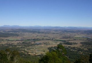 Green Mountains is 115km from Brisbane via Canungra or 70km from the Gold Coast via Nerang and Canungra. The bitumen road is winding and often narrow, and should be driven with great care. The Green Mountains, Lamington National Park protects the largest area of undisturbed subtropical rainforest remaining in south-east Queensland. The 20,500 ha park covers a series of densely-forested valleys and ranges rising to more than 1100m where the McPherson Range marks the Queensland-New South Wales border. Lamington lies on the Scenic Rim, a chain of mountains curving around Brisbane within a radius of approximately 100km. The first European to visit what is now Lamington National Park was Surveyor F. E. Roberts in 1864. He surveyed the interstate border and named many of the high points along this route. From the late 19th century, Robert Collins, a successful grazier and parliamentarian from the Beaudesert district, advocated reservation of a large section of the McPherson Ranges as national park. In 1911 he was joined in his struggle by an enthusiastic young man named Romeo Lahey. Lamington was finally declared in 1915, just two years after Collins' death. The O'Reilly family took up selections in 1911, establishing a farming enterprise. Since the 1902s the family has operated a successful guesthouse at Green Mountains. O'Reilly's (as it's called) has a great restaurant with a view similar to the one I have captured here. The things I was most impressed with here were the absolutley beautiful parrot type birds that fly around here, there were literally hundreds of them all around O'Reilly's. The other things that I loved here, were the walking bridges that went from tree to tree, that were anywhere from 50-75 feet above the ground. An extensive walking track system providing easy access to forests, creeks and waterfalls radiates from Green Mountain. We drove up out of Brisbane to view this area. We spent the day up here (and had lunch) at O'Reilly's, Mt. Tamborine and Lamington then went down and visited a Canugra Valley Winery to finish off our day in the Green Mountains.
|
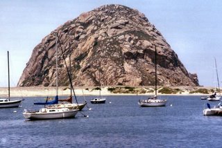 As you can see from the this picture I took, the Rock is actually almost in the middle of Morrow Bay. Few sites are as easily recognized as this one along the coast of central California. Land Area of only 5.08 square miles in the city ofMorrow Bay, San Luis Obispo County. It has a population of just a little more than 9,000 people. Morrow Bay, located about 20 minutes to the West of San Luis Obispo, California and offers a scenic setting which is still within a short commute of many amenities. It is only 30 minutes from the San Luis Obispo Airport. It is located on the famous Hiway 1 which runs along the California coast. White sails dot the horizon as your gaze takes you westward. The chamber of commerce here, touts Morrow Bay as a great getaway from the urban existence. While this may actually be true, because at Morrow Bay natural beauty surrounds you: ocean, mountains, rich rolling hills--and then there's our beautiful harbor and the magnificent Morro Rock. The open ocean picks up the color of the bright blue sky, and there's always a light offshore breeze. Morro Bay is a wonderful place to kick back, relax, enjoy each other, and walk on the beach. There's always lots to do: an 18-hole championship seaside golf course, boating, surfing, kayaking, deep sea fishing (they now even sell yearly and daily sport fishing licenses at the Visitor's Center there), biking, hiking, bird watching and just taking it easy and unwinding. And don't forget they have great local wines. There are also a couple of winery tours locally as well. You’ll experience a wide selection of accommodations from downright luxurious to completely affordable, and we're known for first class restaurants. If you love seafood you simply have to pay them a visit. Once you visit, you'll start dreaming up reasons to come back. We have been there several times over the years and have always enjoyed its quaintness. Something not always easily found on the California coastal area.
|
 This was actually still part of our summer vacation this year. I took this picture literally a couple of weeks ago. You will find Table Rock Lake winding down through the valleys and hollows of the Ozark Mountains, from Branson, Missouri to Eureka Springs, Arkansas. Table Rock Lake reaches out for your attention with water as blue as the sky. Table Rock Lake is famous as an all around recreation lake. There are access areas are provided by the U. S. Army Corps of Engineers. Most have a camping area along with boat launching into the crystal clear Table Rock Lake waters. Designed, built and operated by the U. S. Army Corps of Engineers, Table Rock Lake has become a paradise for boaters, scuba divers, campers and fishermen alike. Camping enthusiasts are treated to thirteen Corps of Engineers operated campgrounds located adjacent to Table Rock Lake. Full service marinas operate on Table Rock Lake at various locations to provide service and convenience to boaters. Over 100 resorts are located adjacent to Table Rock Lake and provide visitors with numerous water-related activities. For those visitors who do not want to operate a boat but still wanting to experience the beauty of the area from the water, five commercial boat cruises or rides operate on Table Rock Lake. This 52,300-acres of Table Rock Lake is known as the clean, clear, warm and blue lake.Thus the 800 miles of shore line is the home of scuba diving through out the year. In the spring, you run into some of the most aggressive bass, crappie, walleye, catfish, spoonbill you will find anywhere. They grow big in a hurry by feasting on baby shad and bluegills. When the Table Rock Lake was built in 1958, they did not clear any of the trees beneath the water level thus there are many cedars and hardwoods on the bottom. This creates very good habitat in which the fish can settle. Table Rock Lake is located among the beautiful hills of Ozark Mountain Country. Because of the Ozark Mountains the coves and scenery along the TableRock Lake vary from shadow to very steep, from meadows to steep rocky bluffs. This offers shadow water as well as deep water for fishing and water sports. The scenery along the banks of TableRock Lake are beautiful, the fishing is great and there are some caves on the banks that visitors like us love exploring. As you may remember from the previous post, on the other side of the dam that created Table Rock Lake, is the location of Lake Taneycomo. Table Rock Lake was very nice and also very picturesque. We all enjoyed our week there. Oh... and for those of you have been to Branson and ridden on the Ducks... this was our first expiernce both in the Ducks and on the lake. They are actually World War II amphibious water/landing craft that can also drive like a bus on the street. They give you these silly Duck (QUACK) whistles that you are supposed to quack at the other tourist-filled Ducks, as you see them on the street. There are only two places int the world that you can ride these vehicles, one is "The Dells" in Wisconsin and the other is right here in Branson, Missiouri. Where this picture was taken is about the same area in which we took the Ducks into Table Rock Lake. They really were a kick!
|
 On vacation this year, we decided to go to a place that none of us had ever been to in the Midwest. Considering what a tourist area this is, it is hard to believe that none of us had ever been there before. It was Branson, Missouri. Right outside of Branson, is a lake called Table Rock Lake, but on the other side of the dam is Lake Taneycomo. I thought of it as looking more like a river than a lake (but what do I know?) We happened to be looking over this lake as the sun was setting and even though the glare of the sun on the lens was difficult to get the camera focused, I managed to get this shot. Lake Taneycomo was created in 1913 as a warm water lake and in 1958 became a cold-water lake when the Table Rock Dam was completed. The clear cold waters from the deep Tail waters of Table Rock Lake pour out of the dam into Lake Taneycomo. These cold waters of Lake Taneycomo provide for some of the finest trout fishing anywhere in the world. All methods of trout fishing, fly-fishing, artificial bait, and live bait fishing may be used year-round to pursue the elusive Trout that inhabit the waters of Lake Taneycomo. Lake Taneycomo originated when the White River was confined by the completion of the "Power Site" Dam, near Forsyth, Missouri. Empire Electric Company privately owns the Power Site Dam. From 1913 until 1958 it was a warm water lake. The completion of Table Rock Dam in 1958 changed the source of water to Taneycomo from that of the White River's flowing waters to the bottom tail water of Table Rock Lake from the dam spillway. This created a cold water fishery. To take advantage of this change the Missouri Department of Conservation constructed the "Shepherd of the Hills Trout Hatchery". Today Lake Taneycomo has some of the best trout fishing in the nation. Lake Taneycomo has the characteristics of both a river and a lake for anglers to enjoy. The shallow colder water, located near the Table Rock Dam, averages 48 degrees F, resembles a river and permits wading and bank fishing for trout. The average temperature of the water gets warmer and the depth of the Lake deepens to depths in excess of 50 feet near Lake Taneycomo and the Power Site Dam in Forsyth. When Table Rock Dam is generating power its current is very strong throughout its whole length, its water temperature drops, and for all practical purposes it becomes a very deep, cold, fast running river. Exactly how deep, cold, and fast depends on how many generators are being used to generate electricity at Table Rock Dam. As for Branson, Missouri, it was very touristy (is that a word?) but we had a nice week there and had a very relaxing week there with our kids and grandkids. The grandkids favorite part is always the pool. I have decided that it doesn't matter where you go or what you do on vaction, but just have a swimming pool for the little kids and it will be a GREAT VACATION FOR EVERYONE!
|
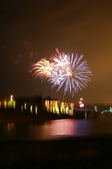
 This is a shot that I took of a local fireworks display out over the lake where our son's in laws live. They had the celebration on Saturday night and we went over there to celebrate as well. The fireworks have always been a sign of celebration as it relates to our declaration of independence from the throne of England and to entitle us to worship in whatever way we as Americans see fit. Of all 56 signers of the Declaration. The first, largest, and most famous signature is that of John Hancock, President of the Continental Congress. The youngest signer was Edward Rutledge (age 26). Benjamin Franklin (age 70) was the oldest. Two future presidents signed: John Adams (second President) and Thomas Jefferson (third President). Here are the words of that document that delared the freedoms that we Americans now all share, thanks to the efforts of many that have given much to OUR FREEDOM! "IN CONGRESS, JULY 4, 1776 ~The unanimous Declaration of the thirteen united States of America.
When in the Course of human events it becomes necessary for one people to dissolve the political bands which have connected them with another and to assume among the powers of the earth, the separate and equal station to which the Laws of Nature and of Nature's God entitle them, a decent respect to the opinions of mankind requires that they should declare the causes which impel them to the separation.
We hold these truths to be self-evident, that all men are created equal, that they are endowed by their Creator with certain unalienable Rights, that among these are Life, Liberty and the pursuit of Happiness. — That to secure these rights, Governments are instituted among Men, deriving their just powers from the consent of the governed, — That whenever any Form of Government becomes destructive of these ends, it is the Right of the People to alter or to
abolish it, and to institute new Government, laying its foundation on such principles and organizing its powers in such form, as to them shall seem most likely to effect their Safety and Happiness. Prudence, indeed, will dictate that Governments long established should not be changed for light and transient causes; and accordingly all experience hath shewn that mankind are more disposed to suffer, while evils are sufferable than to right themselves by abolishing the forms to which they are accustomed. But when a long train of abuses and usurpations, pursuing invariably the same Object evinces a design to reduce them under absolute Despotism, it is their right, it is their duty, to throw off such Government, and to provide new Guards for their future security. — Such has been the patient sufferance of these Colonies; and such is now the necessity which constrains them to alter their former Systems of Government. The history of the present King of Great Britain is a history of repeated injuries and usurpations, all having in direct object the establishment of an absolute Tyranny over these States. To prove this, let Facts be submitted to a candid world.
He has refused his Assent to Laws, the most wholesome and necessary for the public good.
He has forbidden his Governors to pass Laws of immediate and pressing importance, unless suspended in their operation till his Assent should be obtained; and when so suspended, he has utterly neglected to attend to them.
He has refused to pass other Laws for the accommodation of large districts of people, unless those people would relinquish the right of Representation in the Legislature, a right inestimable to them and formidable to tyrants only.
He has called together legislative bodies at places unusual, uncomfortable, and distant from the depository of their Public Records, for the sole purpose of fatiguing them into compliance with his measures.
He has dissolved Representative Houses repeatedly, for opposing with manly firmness his invasions on the rights of the people.
He has refused for a long time, after such dissolutions, to cause others to be elected, whereby the Legislative Powers, incapable of Annihilation, have returned to the People at large for their exercise; the State remaining in the mean time exposed to all the dangers of invasion from without, and convulsions within.
He has endeavoured to prevent the population of these States; for that purpose obstructing the Laws for Naturalization of Foreigners; refusing to pass others to encourage their migrations hither, and raising the conditions of new Appropriations of Lands.
He has obstructed the Administration of Justice by refusing his Assent to Laws for establishing Judiciary Powers.
He has made Judges dependent on his Will alone for the tenure of their offices, and the amount and payment of their salaries.
He has erected a multitude of New Offices, and sent hither swarms of Officers to harass our people and eat out their substance.
He has kept among us, in times of peace, Standing Armies without the Consent of our legislatures.
He has affected to render the Military independent of and superior to the Civil Power.
He has combined with others to subject us to a jurisdiction foreign to our constitution, and unacknowledged by our laws; giving his Assent to their Acts of pretended Legislation:
For quartering large bodies of armed troops among us:
For protecting them, by a mock Trial from punishment for any Murders which they should commit on the Inhabitants of these States:
For cutting off our Trade with all parts of the world:
For imposing Taxes on us without our Consent:
For depriving us in many cases, of the benefit of Trial by Jury:
For transporting us beyond Seas to be tried for pretended offences:
For abolishing the free System of English Laws in a neighbouring Province, establishing therein an Arbitrary government, and enlarging its Boundaries so as to render it at once an example and fit instrument for introducing the same absolute rule into these Colonies For taking away our Charters, abolishing our most valuable Laws and altering fundamentally the Forms of our Governments:
For suspending our own Legislatures, and declaring themselves invested with power to legislate for us in all cases whatsoever.
He has abdicated Government here, by declaring us out of his Protection and waging War against us.
He has plundered our seas, ravaged our coasts, burnt our towns, and destroyed the lives of our people.
He is at this time transporting large Armies of foreign Mercenaries to compleat the works of death, desolation, and tyranny, already begun with circumstances of Cruelty & Perfidy scarcely paralleled in the most barbarous ages, and totally unworthy the Head of a civilized nation.
He has constrained our fellow Citizens taken Captive on the high Seas to bear Arms against their Country, to become the executioners of their friends and Brethren, or to fall themselves by their Hands.
He has excited domestic insurrections amongst us, and has endeavoured to bring on the inhabitants of our frontiers, the merciless Indian Savages whose known rule of warfare, is an undistinguished destruction of all ages, sexes and conditions.
In every stage of these Oppressions We have Petitioned for Redress in the most humble terms: Our repeated Petitions have been answered only by repeated injury. A Prince, whose character is thus marked by every act which may define a Tyrant, is unfit to be the ruler of a free people.
Nor have We been wanting in attentions to our British brethren. We have warned them from time to time of attempts by their legislature to extend an unwarrantable jurisdiction over us. We have reminded them of the circumstances of our emigration and settlement here. We have appealed to their native justice and magnanimity, and we have conjured them by the ties of our common kindred. to disavow these usurpations, which would inevitably interrupt our connections and correspondence. They too have been deaf to the voice of justice and of consanguinity. We must, therefore, acquiesce in the necessity, which denounces our Separation, and hold them, as we hold the rest of mankind, Enemies in War, in Peace Friends.
We, therefore, the Representatives of the United States of America, in General Congress, Assembled, appealing to the Supreme Judge of the world for the rectitude of our intentions, do, in the Name, and by Authority of the good People of these Colonies, solemnly publish and declare, That these United Colonies are, and of Right ought to be Free and Independent States, that they are Absolved from all Allegiance to the British Crown, and that all political connection between them and the State of Great Britain, is and ought to be totally dissolved; and that as Free and Independent States, they have full Power to levy War, conclude Peace contract Alliances, establish Commerce, and to do all other Acts and Things which independent States may of right do. — And for the support of this Declaration, with a firm reliance on the protection of Divine Providence, we mutually pledge to each other our Lives, our Fortunes and our sacred Honor." — John Hancock New Hampshire:Josiah Bartlett, William Whipple, Matthew Thornton Massachusetts:John Hancock, Samuel Adams, John Adams, Robert Treat Paine, Elbridge Gerry Rhode Island:Stephen Hopkins, William Ellery Connecticut:Roger Sherman, Samuel Huntington, William Williams, Oliver Wolcott New York:William Floyd, Philip Livingston, Francis Lewis, Lewis Morris New Jersey:Richard Stockton, John Witherspoon, Francis Hopkinson, John Hart, Abraham Clark Pennsylvania:Robert Morris, Benjamin Rush, Benjamin Franklin, John Morton, George Clymer, James Smith, George Taylor, James Wilson, George Ross Delaware:Caesar Rodney, George Read, Thomas McKean Maryland:Samuel Chase, William Paca, Thomas Stone, Charles Carroll of Carrollton Virginia:George Wythe, Richard Henry Lee, Thomas Jefferson, Benjamin Harrison, Thomas Nelson, Jr., Francis Lightfoot Lee, Carter Braxton North Carolina:William Hooper, Joseph Hewes, John Penn South Carolina:Edward Rutledge, Thomas Heyward, Jr., Thomas Lynch, Jr., Arthur Middleton Georgia:Button Gwinnett, Lyman Hall, George Walton THANK GOD for those who have sacrificed so much for OUR FREEDOM!
|
|


 British Virgin Islands (BVI) is the perfect destination. They are located about 50 miles (80 kilometers) east of Puerto Rico at the eastern end of the Greater Antilles, right smack in the Caribbean Sea. The BVI’s slogan, "Nature’s Best Kept Secret," couldn’t be more true.