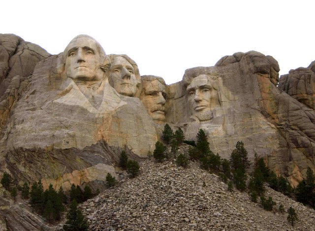
I took this shot a couple of years ago. It was dusk at the Monument and I liked the way the light hit the monument. It somehow seemed like an appropriate post for the long weekend celebration of the USA's Independence Day. The monument itself is hard to comprehend, even when you are standing there looking directly at it. I was on one of the trails that are below it at the time of this shot. The monumnet is carved into the southeast face of a mountain in the Black Hills of South Dakota with the faces of four presidents, as a memorial to American history. The faces of George Washington, Thomas Jefferson, Theodore Roosevelt and Abraham Lincoln look down from their stoney heights and remind everyone that even the impossible is possible. South Dakota state historian Doane Robinson conceived the idea in 1923 to attract more people to the Black Hills of South Dakota with colossal carvings of western heroes. Robinson gained support from major players in South Dakota and Washington DC with the help of Senator Peter Norbeck and Congressman William Williamson. Congress passed legislation authorizing the mountain carving in Harney National Forest Preserve (now Black Hills National Forest). After trying to get another sculptor to do the work, Robinson contacted Gutzon Borglum. Borglum, who agreed to come out to the Black Hills in 1924 to look at the area and see if the carving was possible. The plan was to carve the Needles area into tall granite figures. When Borglum inspected the Needles, he found them to be too thin and weathered to support sculpture on a grand scale. Borglum and the other carving supporters needed to find a new place to carve or abandon the project. It was then they were told about Mount Rushmore. When Borglum saw the mountain he pointed to it and said, "America will march along that skyline." A place had been found to do their carving. Borglum liked Mount Rushmore because it faced southeast which meant it would receive good light throughout most of the day. It was the highest peak in the immediate vicinity, and the granite was very resistant, eroding one inch every 10,000 years. Borglum told Robinson they needed subjects of a national focus. Robinson agreed and Borglum selected George Washington, Thomas Jefferson, Theodore Roosevelt, and Abraham Lincoln. Once they had a carving plan and a location was set, the work could begin. Borglum created a plaster model from which measurements were taken using the pointing system. On October 4, 1927 the first actual work of carving began. Dynamite was used to remove rock from the mountain until there was only a thin, three to six inch layer of granite left. This final layer of granite was removed by a process called "honeycombing". Then the surface was worked smooth with a bumper tool. This left the faces as smooth as a sidewalk. If you want to know how Mount Rushmore got its name; “It’s never had any but it has now-we’ll call the damn thing Rushmore,” the guide, William Challis replied. In the 1880’s Keystone was a booming mining town. James Wilson was a New York mining promoter examining mining claims in the area. Wilson hired Charles E. Rushmore, a young New York attorney, to check on mining titles. Mr. Rushmore arrived in the area in 1885 representing the Harney Peak Consolidated Tin Company, LTD. , located at Pine Camp just north of an “unnamed” mountain. Out traveling to examine claims, Rushmore passed by the unnamed mountain. He asked his guide, William Challis, “What is the name of that mountain?” Challis jestingly replied in his now famous quote. Later, Charles Rushmore donated $5,000 toward the sculpting of “Mount Rushmore.” In June, 1930 the United States Board of Geographic Names officially recognized Mount Rushmore. If you've never been there, I strongly suggest that you make the trip. Custer National Park and the Black Hills of South Dakota are also worth the effort. You can even see the ongoing work of the memorial to Crazy Horse that has been a family effort of the guy who started it some decades ago. It will give you a perspective on what it must have been like to watch Mount Rushmore being built. May you all enjoy this holiday and especially the freedoms that this country allows us all to enjoy. FREEDOM IS NOT FREE! 
|
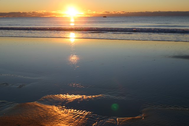
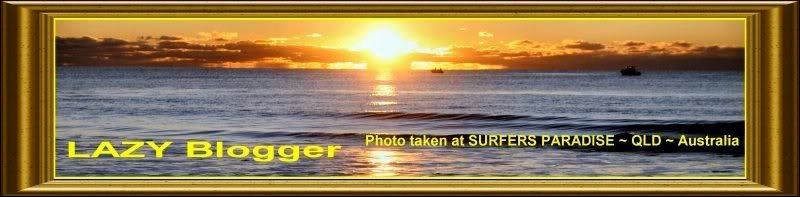
 What better way to start off the new LOOK of my Blogsite, than to use a shot from the one that gave me the whole idea for the "LAZY Blogger" blogsite name. This shot was taken on the same morning as the one on the top of my blog (since its inception). I remember walking out in the early morning at the beach right by our hotel in Surfers Paradise, in Australia. I remember the two pelicans out playing along in the low tide and looking for a little fish for breakfast. I also saw a couple of fishing boats as the sun started to finally show up on the horizon after being blocked by some low clouds that morning. When the sun finally got high enough for me to see the controls on my cameras, I just stated shooting everything that I saw. Surfers Paradise is the most frequented of the Gold Coast suburbs and symbolises what most people would associate with the region. Magnificent high rise apartment towers, outdoor dining, the beach and fun. A concentration of high rise towers dominate the skyline making the other Gold Coast towns look well and truly under developed. This is one of the fastest growing regions in Australia and it is not surprising that one of, if not the World's tallest residential towers, Q1 was compleated in 2005 at 'Surfers'. It stands 80 stories high offering views to as far as Brisbane. Surfers Paradise is adjacent to the more restrained Broadbeach, being connected by the miles of golden beach which gives the area its name. References to surf culture are everywhere from the tall surfboard sculptures at the entrance of the Cavill Mall precinct to the street furniture and outdoor seating. Don't be surprised to see surfers, with their boards in arm, walking to and from the beach. Although the surfing here has a good reputation, dangerous currents and rip tides can get unsuspecting bathers into serious trouble so always swim between the flags on patrolled sections of the beach. At the heart of Surfers Paradise is the bustling, always busy Cavill Mall. This is a pedestrianised precinct running between The Esplanade, on the breachfront, and The Gold Coast Highway. Cavill Mall is lined by fast food outlets, outdoor cafes, bars and restaurants and is the location for buskers and street entertainers, amusement arcades, Ripleys Believe It Or Not, the Hard Rock Cafe and shopping malls. We spent a week at the Marriott Resort in Surfers, but on this particular day, it was truly a memorable morning and one I won't soon forget (especially with about 50 shots of it to remember). I shot it both with 35 MM film and digitally. I hope you enjoy it as much as I did. (But I don't know HOW that would be possible!)
|
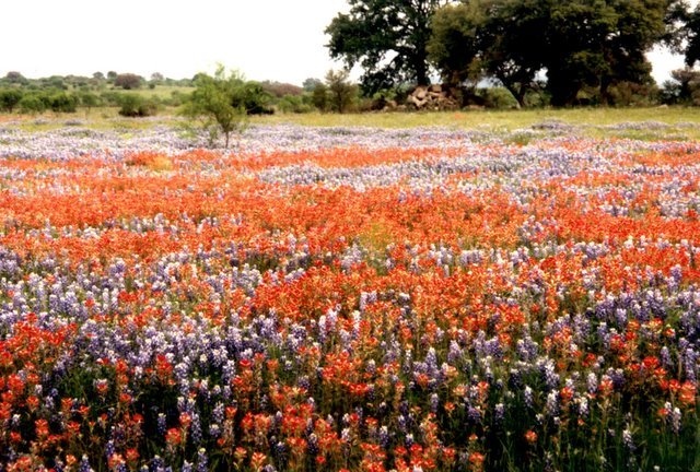
 The BLUEBONNETS of Texas ~ This shot came from a trip to San Angelo, Texas, where we went to celebrate my wife's aunt's 100 th. Birthday. Having always been a Californian, I never knew what bluebonnets were. Or the fact that they have been loved since man first trod the vast prairies of Texas. Indians wove fascinating folk tales around them. The early-day Spanish priests gathered the seeds and grew them around their missions. This practice gave rise to the myth that the padres had brought the plant from Spain, but this cannot be true since the two predominant species of bluebonnets are found growing naturally only in Texas and at no other location in the world. As historian Jack Maguire so aptly wrote, "It's not only the state flower but also a kind of floral trademark almost as well known to outsiders as cowboy boots and the Stetson hat." He goes on to affirm that "The bluebonnet is to Texas what the shamrock is to Ireland, the cherry blossom to Japan, the lily to France, the rose to England and the tulip to Holland." Texas actually has five state flowers, more or less, and they are all bluebonnets. The five colors of the Blue Bonnets are: White, Pink, Maroon, Blue and Red. I think you can see a few of each of these in the picture here. Technically, the other colors are called things like White Bluebonnets, but they just call the blue ones bluebonnets. Whatever they call them, they are just a lovely sight growing wild on the prairies of Texas. "A vacation is having nothing to do and all day to do it in." ~ Robert Orben
|
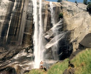 The 317 foot Vernal Falls are one of the many powerful waterfalls within Yosemite National Park, (although we were there long after the heavy spring run off. The falls are not visible from the main valley but easily reached along a well-marked path that begins near the Happy Isles Nature Centre - this in turn is half a mile from the end of the publicly accessible roads and is served by a shuttle bus. The path is level at first although sandy and rocky, and is often quite crowded. It winds through wooded land just north of the Merced River - a fast-flowing boulder-filled whitewater torrent with many small rapids and cascades. The view looking back towards Yosemite Valley gets more dramatic as the path gradually ascends. Mist Trail as it is called (which is how we got to the falls) is a foot path that crosses the river on a wooden bridge, where there is a (seasonal) supply of drinking water, and then continues upstream on the south side, becoming steeper near the falls. This particular part of the path is known as the Mist Trail since the whole area just below is continually dampened by spray, hence the rocks are covered with moss and other water-loving plants, and the trail becomes quite slippery. If the sun shines, transient mini rainbows form, and change shape as the spray is wafted in the breeze. The total elevation gain along the 1.5 mile walk to this point is 1,000 feet. The path continues to the even more spectacular Nevada Falls, 2 miles upstream. But we didn't make it any further than this point. In fact that small half naked body at the bottom of the falls is none other that the LAZY Blogger (which means I didn't actual take this shot) but I did set it up and it was my camera, so I guess that sort of counts! "Don't just dream about life! Live it!" ~ LAZY Blogger
|
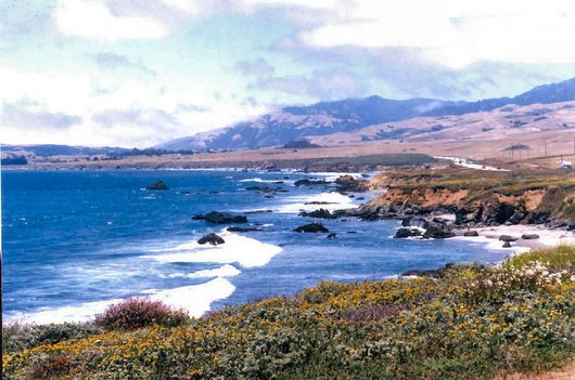
 I took this shot on vacation one year of the beach at San Simeon State Park that is one of the oldest (and in my opinion prettiest) of the California State Park System. The coastal bluffs and promontories of the scenic park offer unobstructed views of the ocean and rocky shore. The park includes the Santa Rosa Creek Natural Preserve, the San Simeon Natural Preserve and the Pa-nu Cultural Preserve were established in 1990. A 3.3-mile trail runs through parts of the San Simeon Natural Preserve and the Washburn Campground. The trail includes scenic overlooks, rest-stop benches and interpretive panels with information on wildlife and habitat. San Simeon State Park is located 35 miles north of San Luis Obispo on Highway 1, and 5 miles south of the Hearst San Simeon State Historical Monument Visitor Center. The community of Cambria is located 2 miles to the South and offers gas stations and grocery stores. While there we visited the Hearst Castle, which in and of itself is spectacular. If you ever get there, I would highly recommend touring the castle there too. "The earth belongs to anyone who stops for a moment, gazes, and goes on his way." ~ Colette
|
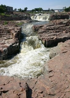 I took this shot from a tower that is futher down the river from the actual Falls themselves. The almost mystical allure of the Falls has always been a powerful influence. This special place of natural beauty has been attracting visitors ever since the earliest prehistoric peoples occupied the great northern plains. Sioux Falls exists as a city today because the land speculators who staked town site claims here in 1856 came in search of the cascades, inspired by stories of their impressive beauty and power. It is on the three corners where the states of South Dakota, Iowa and Nebraska all come together. There is a nice park there with lots of folks having picnics and family reuniouns in that area. Fall Park (as it is called) has been dramatically transformed in recent years by comprehensive improvements, effectively reversing decades of neglect and decline. The great scenic beauty of the Falls is now complemented by a beautiful park setting. Many new visitor amenities have been built, dense volunteer scrub brush has been cleared, alcohol has been banned from the park, and an intensive system of historic-style pedestrian lights makes Falls Park a safe, well-illuminated place after dark. Large floodlights illuminate the cascades themselves. The park is an inviting family environment day or night. We enjoyed our time there. "The true way to live is to enjoy every moment as it passes, and surely it is in the everyday things around us that the beauty of life lies." ~ Laura Ingalls Wilder
|
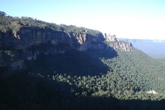
 I took this shot of the Blue Mountains on a cloudless and perfectly clear day. Although to us ex-Californians, it may look like smog. But actually, the Blue Mountains have been given their name due to the blue haze that hovered above the mountains produced by the oil from the plentiful Eucalyptus trees (which you can see just cover these mountains and valleys). The Blue Mountains of Australia offer spectacular scenery, plantlife and wildlife. The mountains reach a height of 1100m, and The Three Sisters (they are the three rock formations at the upper right part of the photo off from center) are a famous rock formation in the Blue Mountains of New South Wales, Australia. They are close to the town of Katoomba and are one of the Blue Mountains' most famous sights, towering above the Jamison Valley. Their names are Meehni (922 m), Wimlah (918 m), and Gunnedoo (906 m). The Sisters were formed by erosion. The soft sandstone of the Blue Mountains is easily eroded over time by wind, rain and rivers, and the cliffs surrounding the Jamison Valley are being slowly broken up. Leura is a small and pretty town which offers a number of cafes and dainty stores. We stopped and had an English High Tea there in an old hotel called the Imperial Hotel. They called it High Tea, but I called it LUNCH! Just south of this area is Sublime Point a great lookout (and where I took this shot from). For great views of the Jamison Valley and of course to see the spectacular Wentworth Falls head to Wentworth Falls. Between Leura and Wentworth Falls is Katoomba which is the main tourist center and viewing area for the Three Sisters. The Blue Mountains were once thought of as the barrier to freedom, with many early settlers believing China was on the other side. 25 years later Europeans crossed the mountains and soon after a road was built to the other side. Although there are various Aboriginal markings few Aborigines were found in the Blue Mountains, thought to have been wiped out by disease. Formations like the Three Sisters are created when water seeps into small cracks in the rock, gradually enlarging them over time to form large indentations. Eventually, the Sisters will be eroded away completely. Indigenous Australian Dreamtime legend says that three sisters fell in love with three men from a neighbouring tribe, but marriage was forbidden by tribal law. Battle ensued, and the sisters were turned to stone by a witch doctor to protect them, but he was killed in the fighting and no one else could turn them back. Tough (and rocky) life for women way back then! Please pardon my pun!
|
|


 I took this shot a couple of years ago. It was dusk at the Monument and I liked the way the light hit the monument. It somehow seemed like an appropriate post for the long weekend celebration of the USA's Independence Day.